The 1930s: The Era of Ground Water Development
LeRoy W. Hooton, Jr.
November 8, 1999
In 1928, Salt Lake City impaneled a water Advisory Board to find a water supply for a minimum population of 400,000 people. The Boards final report became the springboard for water development that produced over 100,000 acre-feet of new water supply during the following decades. Subsequently, Salt Lake City developed water through the Provo River Project and increased local supplies by expanding water exchanges with the farmers who had appropriated the Wasatch Canyon streams. This paper describes how Salt Lake City developed its ground water supply during the drought of the 1930s.
Early Ground Water Studies
Ground water was studied, but not considered the first choice for development; however, the drought of the 1930s changed the Citys priorities. The City considered the Provo River Project and Deer Creek Reservoir and the Argenta Dam in Big Cottonwood Canyon as its top two priorities. The Metropolitan Water District of Salt Lake City was formed in 1935 to build the Provo River Project. The construction of the project and the Salt Lake Aqueduct necessary to deliver water to Salt Lake City would not be completed until 1951. The other choice, the 12,000 acre-foot Argenta Dam project, was defeated in a May 6, 1930 bond election.
|
There were also legal ramifications in developing ground water. In a report written by City Attorney Shirley P. Jones, he wrote, The common law doctrine that the owner of the surface owns everything beneath it has no application in Utah in so far as it affects water beneath the surface. The Utah law is that every proprietor of land in an artesian district is entitled to water in proportion to his surface area provided he makes a beneficial use of the water. This would require the City to not only acquire the water rights, but the land overlying the basin. There was additional concern over acquiring ground water rights, yet being enjoined from using it, if other water right holders were affected by withdrawing the water and lowering the ground water table. Moreover, there was concern expressed over water that surfaced and had been appropriated by other water users. He concluded, It is therefore apparent that if the City should undertake development of underground water, it would almost certainly be forced into a position of being enjoined from using the water it had developed if the same interfered with correlative rights of other land owners in the artesian basin, or interfered with prior appropriation of persons using the water after it had reached the surface and was flowing in natural channels thereon.
The City had already experienced one failure to develop ground water when it purchased 160 acres of land near the Jordan River in Lehi, Utah. One hundred thirty-two wells were drilled that produced 3,000,000 gallons per day of water supply, lowering the ground water levels in the area. This brought suit against the City, and in 1930 it was enjoined from operating the wells. Later the wells were capped. This experience was fresh in the minds of City officials.
Fairbanks-Morse Water Supply Company submitted a bid to the City to drill its wells, but were not awarded the contract, for the reasons stated above. Furthermore under their proposal the City would be liable for any and all claims arising from drilling and using the wells. On January 28, 1930 the City Commission formally rejected their bid. According to the recommendation submitted by Mayor Bowman, Underground water should not be developed as a major project but only as a supplemental supply. Our present surface water supplies should be perfected first...and the underground supply will always be here and can be developed in the future when the City may deem it advisable...
The Drought
|
Less than normal precipitation began in the late 1920s. By the summer of 1930, the City had to impose restrictions on outside watering. The water level of Utah Lake began to drop below the compromise level in 1926 and continued to dip lower as there was not adequate snowmelt to fill the lake compared to the amount of water withdrawn during this same period. For nearly 25 years the lake level would be below the agreed upon compromise level of the lake of 4489.35 feet.
The winter snowpack measurements during the winter of 1930-1931 were again below average, forcing City officials to consider emergency measures.
On April 2, 1931, the City Commission approved an emergency plan and raised water rates 33 and 1/3 percent to fund additional water development. Ground water development and acquiring additional water from the local canyon streams were the immediate action items.
A survey of the artesian basin in the Murray area was made by Dr. Fredrick J. Pack and Professor William Peterson, Utah Geologist and past member of the 1929 Water Advisory Board. Their assignment was to determine the quantity of water and land surface rights the City needed.
On May 1, 1931 a contract was awarded in the amount of $257,713.50 to Morrison & Knudsen Company to construct a 36-inch pipeline and pumping plant to convey the artesian waters to Salt Lake City.
A $2 million bond election was held and approved by the voters on July 1, 1931 to fund the drought relief program.
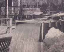
The Little Cottonwood Conduit was constructed to convey water from Little Cottonwood Creek to Salt Lake City.
The Drought Deepens and Salt Lake City begins Drilling Wells
|
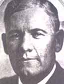
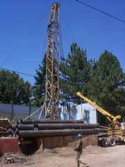
During December 1933, City officials led by newly elected Commissioner George D. Keyser, undertook a program to develop water trapped deep beneath the earths surface. Following a 1932 report prepared by the United States Geological Surveys R. M. Leggette, geologist, and C. H. Taylor, engineer, the City began a well drilling program on the bench lands west of the Wasatch Mountains where the USGS identified the most permeable water materials existed.
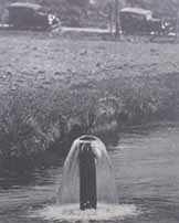
In February 1934, the first well was completed. The well was drilled at the head of the Richards Ditch on Little Cottonwood Creek and produced 2.5 cfs. A month later the Mill Creek Well was completed. Located near the head gates of the White Ditch, this well produced 2.8 cfs. Both wells provided immediate relief by providing water to exchange farmers, allowing the City to divert more water from the two streams into the culinary water system.
The well drilling program was expanded to a total of 15 wells drilled, producing over 50 cfs. City officials were delighted with the result of the program. The wells provided immediate drought relief. Some were pumped directly into farmers ditches to meet exchange obligations, while others were pumped into the water distribution system. In total 2, 530 acre-feet of water was produced by the new deep wells in 1934.
1934 is the driest year on record in Utah. According to annual stream flow records, only 54,106 acre-feet of water flowed from the seven Wasatch Canyon streams, 50 percent lower than normal.
Utah Lake Water Levels Decline
Utah Lake, the source of water used by Salt Lake City to meet its exchange obligations, hit its lowest levels in 1934 and 1935 when the lake essentially dried up. The water level dropped 11.0 feet below compromise level in 1934 and 11.5 feet in 1935. This compares to only 8.0 feet below compromise level in 1992, the most recent drought level. In 1992 water could not be pumped from the lake, and it was necessary for Salt Lake City to release drinking water into the farmers ditches to complete the exchanges.
On August 2, 1934 in order to pump the deepest recesses of the lake, an emergency plan was placed into operation. Earlier Governor Blood approved the Drought Relief Project, making relief funds available from the Utah Emergency Relief Administration to construct the Pelican Point Pump Plant on the west side of Utah Lake. The plant an 8-mile canal conveyed 52.3 cubic feet per second of water to the Associated Canal Companies, (including Salt Lake City), saving over one million dollars in crops during the 1934 growing season. This project helped Salt Lake City provide additional exchange water to the farmers and divert more canyon stream water into the culinary water distribution system.
The Drought Ends
|
Modern-day Ground Water Use
Ground water is an important part of Salt Lake Citys water supply. The artesian basin and wells drilled during the 1930s have been augmented over the years with additional drilled wells. The water levels in the artesian basin have lowered to a point that today the artesian flows have decreased. Its necessary to pump the basins to produce the water supply.
|
Over the years it has been necessary to rework the wells drilled in he 1930s. Extensive work was completed on the 2700 South 1300 East Well in 1981. The well had become a sand pumper and it was necessary to screen it. In 1998, the Mill Creek Well was redrilled and a new pump station constructed during 1999-2000. In 1999, the 6200 South Well was reworked. Some of the original wells drilled in 1932 34 have been abandoned. The others have been up-graded to meet changing standards.
The newest well is the Walker Lane Well located on Highland Drive and Walker Lane. It was drilled and equipped in 1991. A new well is planned for the mouth of Red Butte Canyon in 2001.
Conclusion
The drought of the 1930s forced Salt Lake City to look at developing its ground water supply. City officials wanted to construct the Argenta Dam in Big Cottonwood Canyon to develop 12,000 acre-feet of new water supply, but the voters failed to support this proposal in a bond election. The Provo River Project and construction of the Deer Creek Reservoir on the Provo River was a long-term project and in the short run could not provide water during the deepening drought of the 1930s. City officials recognized their desperate need for drought relief water to meet the Citys culinary water needs. Their expediency in acquiring the artesian basin and constructing pipelines to convey its waters to the city and drilling wells to produce over 50 cfs of water between June 1932 and October 1934 is a remarkable feat and demonstrates the Citys unfailing commitment to its citizens.
These ground water supplies have continued to provide Salt Lake City a dependable water supply. Today they are an essential component of the Citys water supply.